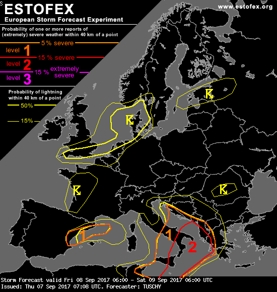
Allerta Meteo – Anche Estofex (European Storm Forecast Experiment) lancia un allarme per il forte maltempo in arrivo nelle prossime 12-18 ore al Centro/Sud Italia. L’allarme massimo, di livello 2, vale per tutte le zone joniche di Sicilia, Calabria, Basilicata e Puglia, e per il basso Adriatico tra Bari, Brindisi e Salento. Attenzione anche al basso Tirreno. Allerta di livello 1, invece, sul resto di Sicilia e Centro/Sud.
Il bollettino Estofex prevede grandine “molto grossa” e “isolati tornado”.
Il maltempo sarà provocato dallo scontro tra le masse d’aria caldo-umide in risalita dal Maghreb, dalla Tunisia e dalla Libia, e quelle più fredde in discesa dall’Adriatico.
Molto interessante l’analisi sinottica di ECMWF, che è tecnica ma estremanente esplicativa in termini scientifici sul forte maltempo in arrivo. Ecco perchè “non si possono escludere tornado”, come spiegano gli esperti europei:
As the LL depression over Tunisia/Libya intensifies and moves offshore, a confluent flow regime pushes LL mixed-layer mixing ratios to values in excess of 16 g/kg with TPWs of 40 mm below an EML. This moisture plume expands NE all the way to the Ionian Sea and outruns the EML which results in lower CAPE. A plume of 1.5 to 2.5 kJ/kg moderately capped MLCAPE resides south of Sicily, although degree of LL moisture content seems to limit cap strength at least along the northern fringe. CAPE decreases to 1 to 1.5 kJ/kg MLCAPE over the Tyrrhenian and Ionian Sea.
Strong synoptic-scale forcing accompanies the upper-level trough and spreads out to the north and south during the lifting stage (affecting an area from the S-Adriatic Sea to Libya).
Therefore expect CI all day long with convection ongoing from the previous night (especially between Sicily and Tunisia).
However, models like GFS suppress substantial DMC activity for most of the time until 12 UTC over Sicily. A reason for that could be lowering BL moisture from the NW as very dry air from a Mistral event over S-France (TPWs between 10-15 mm spreading SE) seems to approach Sicily before noon with GFS inidcating strong diurnal mixing and hence a lack of CAPE. A tight moisture gradient evolves just south of Sicily and with some backing of the LL flow in response to the evolving depression the very moist air mass should be pushed back to the north to S- and E-Sicily during the afternoon hours – adequate for CI.
A substantial increase in DMC activity is expected from S-/E-Sicily to the S-Tyrrhenian Sea, S-Italy and the Ionian Sea ahead of the upper trough beyond 12Z to 15Z. 20 m/s DLS is enough for organized multicells and isolated supercells with large hail (a very large hail event is possible), severe wind gusts and excessive rain. The severe wind gust risk increases during the night over the Ionian Sea and W-Greece both due to enhanced probabilities of an upscale growing thunderstorm cluster and 0-3 km shear in excess of 20 m/s. A few damaging wind events can’t be excluded.
The same for the excessive rainfall risk due to a strengthening low-tropospheric wind regime, increasing the chance for temporal training with a V-shaped cluster along the W/NW-coast of Greece. Further north over the S-Adriatic Sea, slow moving convection poses an excessive rainfall and isolated waterspout risk as shear relaxes in that area. A waterspout risk also exists over the Tyrrhenian Sea (with hail and wind hazards increasing over the far S-Tyrrhenian Sea).
Finally an area between S-Sicily and Malta has to be emphasized. The aforementioned impressive BL moisture and backed LL flow north of the LL depression create a favorable environment for tornadic thunderstorms in case of CI. Discrete storm structure is more likely due to the strengthening cap, so a strong tornado event can’t be excluded.
Ecco le pagine utili per seguire la situazione meteo in tempo reale: