

 Hurricane Irene:
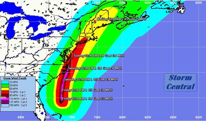
According to reconnaissance aircraft, Irene has weakened a little. I fully expect Irene to regain major hurricane status today as there appears to be a new eyewall forming according to reconnaissance reports and this new eyewall should contract causing the pressures to fall and the winds to increase. Irene is currently tracking due north at a forward speed of 13 to 14 mph. The overall track model guidance is in pretty good agreement on a northward track today into tonight and then a north-northeast track on Saturday. Irene is expected to make landfall very close to Cape Lookout, North Carolina as a Category 3 hurricane early Saturday afternoon and then track across Pamlico and Albemarle sounds in eastern North Carolina during the late afternoon hours of Saturday. Irene is then expected to track very near the Mid-Atlantic coast as a Category 2 hurricane on Saturday night before making landfall on the southern New England coast just west of New London, Connecticut as a 95 to 100 mph hurricane right around early afternoon on Sunday. From there, Irene will track northeastward across central Massachusetts, southeastern New Hampshire and southwest Maine as a weakening Category 1 hurricane from late Sunday afternoon into Sunday evening. By late Sunday night and into Monday morning, Irene is forecast to track across central and northern Maine as a tropical storm before exiting into the Canadian Maritimes late Monday morning.
Irene is a very large hurricane in its overall size and the effects from Irene will be felt far away from the center of the storm. In fact, tropical storm force winds extend out up to nearly 300 miles from the center.
Expected Impacts & Approximate Timing:
Eastern North Carolina and the Outer Banks of North Carolina:
Tropical storm force winds will reach the southern portions of the eastern North Carolina coast by early this evening with deteriorating weather conditions expected tonight across all of eastern North Carolina. Bands of heavy rainfall will rotate across eastern North Carolina throughout the night tonight with tropical storm force winds spreading inland west of Highway 17 by late tonight. Hurricane conditions will reach southern parts of eastern North Carolina during the pre-dawn hours of Saturday morning.
During Saturday, hurricane conditions are likely along and east of Highway 17 throughout the day with winds exceeding 100 mph along the immediate coast. A storm surge of 6 to 12 feet with locally higher amounts are likely. Total rainfall amounts of 6 to 12 inches are likely throughout eastern North Carolina with widespread inland flash flooding likely. Conditions will slowly improve during Saturday night and into early Sunday morning.
If you have been told to evacuate by your local emergency management officials, please do so.
Virginia, Maryland, Delaware, New Jersey and New York:
A storm surge of 4 to 8 feet above ground level is expected across southern parts of Chesapeake Bay and the eastern shore of the Delmarva Peninsula. A storm surge of 3 to 6 feet above ground level can be expected along the Jersey Shore. Hurricane force winds are expected right along the immediate coast of New Jersey and across the Delmarva Peninsula from Saturday night into Sunday morning. Total rainfall amounts of 6 to 12 inches are expected across this entire area with widespread flash flooding likely.
I urge everyone that if you are told to evacuate by local emergency management officials, please do so.
Southern New England:
Irene is expected to have a very significant and damaging impact on southern New England. The exact track of Irene across New England will have large implications on how strong the winds will be and how high the storm surge will be. The latest model guidance has a track that takes Irene across eastern Connecticut and western Rhode Island north-northeastward into central Massachusetts in between Route 495 and 395.
A classic heavy rain event, called a predecessor rain event (PRE), will occur on Saturday night across all of southern New England. The main impact from Irene will occur from Sunday into Sunday evening with slowly improving weather conditions after midnight Sunday night.
Heavy rain with moderate to major flooding is likely across all of New England. 6 to 12 inches of rainfall is expected across southern New England from Saturday night to Sunday night. Locally higher amounts are possible across western Massachusetts and western Connecticut. Across northern New England, 6 to 12 inches of rain with local amounts of up to 15 inches are likely from Sunday afternoon to midday Monday. Moderate to major urban and river flooding is likely across all of New England.
Very strong winds of up to hurricane force are likely across eastern Connecticut, much of Rhode Island, eastern Massachusetts and Cape Cod. Widespread power outages and tree damage seems likely and extended power outages lasting for days may be possible across much of southern New England. Everyone across southern New England should be prepared for these possible extended power outages.
A large and potentially destructive storm surge is possible mainly along the south coast of southern New England for both the Sunday morning and Sunday evening high tides. Everyone along the south coast of southern New England needs to prepare for the possibility of up to a 10 to 15 foot storm surge depending on the exact time Irene makes landfall in relation to the tide level.
Preparedness Tips:
Hurricane Watches and Warnings are currently in effect from southern New England southward to the eastern coast of North Carolina. Everyone that is in a Hurricane Watch or Warning needs to take this hurricane very seriously and make preparations to minimize your loss and potentially save your life.
Widespread power outages are likely. Trees and utility lines will be down in many areas from eastern North Carolina to southern New England. Numerous roads will also be blocked by debris. Make sure you have enough food and water to last several days. In addition, make sure that you have an adequate supply of essential medicine and other medical supplies. When the power is out in your local area, you will not be able to use many things like gas pumps, ATM machines and cash registers. Fill up your vehicle and withdraw enough cash to last you several days in case you need it.
If you live in a Mobile home, make plans now to evacuate to a safer place. Mobile homes are not safe in hurricane force winds.
If you live in a sturdy structure that is on high ground, prepare it for hurricane conditions: Cover large windows with shutters or sheets of plywood; Close drapes across windows to protect against flying glass if shattering occurs; Remove loose objects from porches, patios and decks; Brace garage doors and avoid opening any door on the windward side of the structure; Keep battery operated radios nearby to continuously monitor local news media on the progress of the hurricane.
For full information on Hurricane Irene, go to our Hurricane Irene page at http://hurricaneauthority.wordpress.com
Finally, I urge everyone from eastern North Carolina to southern New England to take this hurricane extremely seriously.
Elsewhere In The Tropics:
Other than hurricane Irene, there are no other areas of disturbed weather that are expected to threaten/impact land over the next several days, at least. Tropical Depression #10 is very weak and will eventually track into the open Atlantic. The long range GFS model forecasts that a couple of tropical disturbance now over the continent of Africa will need to be monitored later next week as they are forecast to track towards the Lesser Antilles. This is something that I will be keeping an eye on over the next several days.
 Vuoi ricevere le notifiche sulle nostre notizie più importanti?