di Andrea Muscat – Il passaggio di un fronte freddo sul Mediterraneo centrale e sull’Italia meridionale ha portato la formazione e lo sviluppo di numerosi temporali forti e organizzati che hanno interessato solo il nord-ovest e la costa nord-orientale di Gozo nel pomeriggio di ieri, mantenendosi prevalentemente in mare. Una delle tempeste che ha influenzato le isole maltesi è stata un sistema convettivo a mesoscala che aveva iniziato a formarsi nel mattino e ha poi raggiunto la maturità nel pomeriggio, quando ha martoriato le isole maltesi e soprattutto Gozo con forti piogge, raffiche di vento forti, grandine e un tornado avvistato da alcuni, anche se non documentato. Il maltempo è durato solo 30 minuti con debole pioggia ininterrotta che ha insistito poi per circa un’ora. Le precipitazioni totali di questa tempesta non sono state certo eccezionali, con 14,1 millimetri al Gharb, con una maggiore quantità di oltre 20 mm in alcune parti di Gozo. Ciò perchè la pioggia è stata guidata dal forte vento causando precipitazioni che impediscono l’accumulo di pluviometri, con le gocce d’acqua che arrivano al suolo in modo orizzontale. La raffica massima vento è stata misurata a 85,3 kmh (Forza 9) alle 3:14 pm. La tempesta ha anche prodotto alcune grandinate che però sono state di piccole dimensioni. La tempesta ha anche provocato frequenti fulminazioni nube-suolo in molti settori di Malta. A causa del fatto che le vallate erano asciutte e che i campi erano stati appena arati, non ci sono state inondazioni. Questo tipo di attività è assolutamente normale per questo periodo dell’anno, anche su Malta.
Mesoscale Convective System Hits Maltese Islands
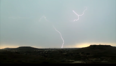
The passing of a cold front over the Central Mediterranean and most of Southern Italy brought about the formation and development of several strong and organized thunderstorms which affected only the northwestern and northeastern coast of Gozo as they remained out at sea. One of the storms which did affect the Maltese Islands was a Mesoscale Convective System which started forming in the morning and reached maturity in the afternoon. It battered the Maltese Islands especially Gozo with heavy rain, severe wind gusts, hail and unconfirmed reports of a funnel cloud. This state of affairs lasted only 30 minutes with steady light rain lasting for around an hour. Rainfall totals from this storm were not very high with 14.1 mm being measured at Gharb with higher amounts of over 20 mm in some parts of Gozo. One reason for this was that rain was wind driven causing preventing rainfall from accumulating in rain gauges at times. The highest wind gust was measured at 85.3 km/h (Force 9) at 3:14 p.m. The storm also produced some hail which however was only small to moderate in size. An unconfirmed funnel in Gozo was also reported by some. The storm also produced frequent cloud to ground lightning which touched the ground in several areas. Due to the fact that valleys were dry and that fields had just been ploughed and were very dry flooding caused by the storm soon eased off. This type of activity is normal for this time of year.
 Vuoi ricevere le notifiche sulle nostre notizie più importanti?